If you're considering a unique destination on Earth, Waqrapukara should definitely be on your list. This historical and cultural monument is an exceptional showcase of the process of civilization in the southern Andean region. It features expressions from various pre-Inca ethnic groups that emerged around 3000 BC and the Inca period, indicating continuous occupation of these territories over different eras.
This ceremonial center was dedicated to the god Tecsi Pachacamac Wiraqocha, where offerings were made to the moon and the sun, making it one of the most significant sites after the Raqchi temple during the Inka period. Its status as a sacred site continues to this day, symbolizing the convergence of two worlds (the earthly and the divine) and marking a foundational moment in national identity. Read on to discover all about Waqrapukara!
Where is it?
The Archaeological Landscape of Waqrapukara is situated on the right bank of the Percca River in the Percca estate area within the Huayqui community, Acos district, Acomayo province, and Cusco department. Its UTM coordinates are east 0209008.2600 and north 8448423.2630, at an altitude of 4,110 meters above sea level.
Meanings of the word Waqrapukara
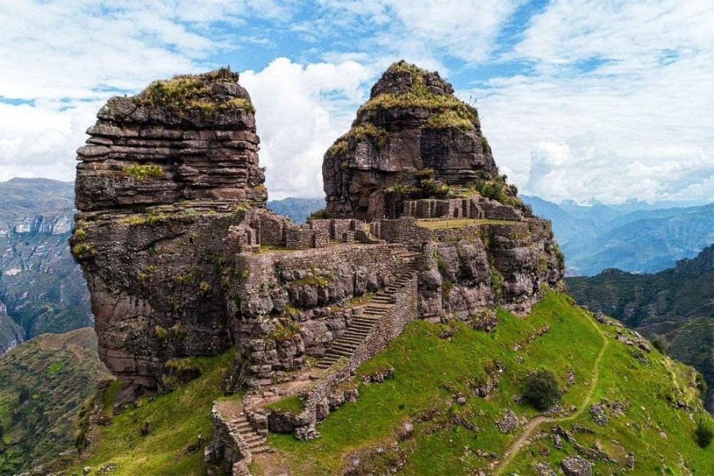
Originally, Waqrapukara was called “Llacta Pucara,” home to several families, thus named Llaqtapukara—llaqta, meaning a populated center and pucará, indicating it was a place of worship. During the Inca era, Wayna Qhapaq transformed it into an astronomical observation center. Another name for Waqrapukara was “Huayqui” or “huayqe” due to a pair of whimsically shaped rock formations considered "brothers," now identified as horns. The most recent and well-known name, “Waqrapukara,” derives from two Quechua words, huacra=cuerno (horn) and pucará=fortress, referring to two prominent geological formations resembling horns.
History of Waqrapukara
Pre-Inca Era
Waqrapukara was initially populated by the "Chelqes" and "Maskas" ethnic groups. Once the K'ana nation settled in these territories, another clan took over the area around Pomacanchi and Acomayo, giving rise to the Qanchi ethnicity, which inhabited the nearby Paqarinas of Waqrapukara, Tambomayo, Puma Orqo, Willkacalle, Suyt’upukara, Qero, and Pumawasi. From here, the Qanchis began to expand their territory, establishing themselves in the highlands at pukaras like Machupitumarca and Salqapukara, and in the high areas of Salqamayo.
During the late intermediate period, the Qanchis had direct contact with the Parureños, who came to Waqrapukara to offer their Colcha-style pottery. At the same time, the Killke people, also known as the Early Inca, inhabited the site for a long period until the arrival of the Incas.
Inca Era
Initially, Waqrapukara was built as a 'llaqta' by the Qanchis. Around 1000 BC, during the Auqarunas period, it was transformed into a 'pukara' aimed at defending their territory from other ethnic groups. Here, conflicts arose between the K'anas and Qanchis, and the K'anas and Chumpiwillkas, with the Chumpiwillkas coveting Llaqtapukara for its maize crops. This led to the uprising of Ttito Qosñipa against the Inca army, making it the last refuge for the Qanchi ethnicity and turning it into a fortress.
Once the Qanchis were subdued by the Incas, they had indirect control over the Qanchis. When T'ito Qosñipa rose to the rank of General in the Inca army, he improved and reorganized the architectural structures at Waqrapukara, which is why we find Inca constructions of great significance here.
Colonial Period
In 1581, the province of Acos was mentioned in the Provisions of Viceroy Toledo as part of the repartition of Cusco.
In 1613, an ecclesiastical division of Cusco took place, dividing the region into 13 corregimientos, with Acomayo forming part of the 4th corregimiento of Quispicanchi.
Present Day
Today, Waqrapukara is recognized as an archaeological landscape, protected by the Ministry of Culture Cusco and the residents of Acomayo and Huayqui. It is a new, less frequented tourist destination, where visitors can still freely enjoy the landscape without spending much money. Around noon, we can observe the flight of condors, with a bit of luck seeing more than 20 specimens soaring through the skies, offering a unique experience.
How to get to Waqrapukara?
Access to the archaeological landscape is via four routes, starting from the city of Cusco towards Sicuani, then diverting at Chuquicahuana bridge towards:
- Acos: Once in the district of Acos, proceed to the town of Ch’acco, then pass through Llapaypampa, Campi-P’alta Cancha, and finally reach the Huayqui Community, from where a 30-minute uphill hike begins, followed by an extended 15-minute path to Waqrapukara.
- Acomayo: Two alternatives lead to Waqrapukara from Acomayo. One is from Ramal Huáscar, then to the town of K´enter, and finally to Waqrapukara. The other is through the Community of Pitumarca, passing through the town of Paclla to reach Waqrapukara.
- Pomacanchi: Two routes are available from the district of Pomacanchi. From Acomayo, head to the town of Churacca, then pass through the Community of Santa Lucía to reach the road of Santa Lucía. Then, follow a 45-minute hike to Waqrapukara. This is the most frequent route for visitors. Another route is via the town of Chosecani to Waqrapukara.
- Sangarará: From the district of Sangarará, take a track to Llank’ipata, then embark on a two-hour downhill hike to Waqrapukara.
Best Time to Visit Waqrapukara
The recommended months to visit Waqrapukara are from May to October, during the dry season. The site has a camping area, allowing visitors to freely set up tents and enjoy the archaeological site and the surrounding landscape.
Weather
The climate is semi-dry and cool with a dry winter, marked by rainfall during two distinct seasons, with an average annual temperature of 12°C to 14°C. The rainy season runs from December to March, and the dry season from May to July.
What to See at Waqrapukara?
The archaeological Site
The impressive archaeological site of Waqrapukara once served as a ceremonial center dedicated to the god of the Qanchis: Teqsi Pachacamaq Wiraqocha, the creator of the world. It was built to commemorate and remember the Creator of the sun, the moon, and the stars. Waqrapukara was a sanctuary dedicated to the sun and the moon, where sacrifices of camélidos of different colors (llamas and alpacas) were offered, unlike the sanctuary or temple of the God Tecsi Pachacamaq Wiraqocha at Raqchi, which was dedicated to offerings.
Places within the Archaeological Site of Waqrapukara
The site features five accessible sectors:
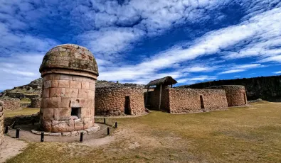
Main Plaza: The central plaza is located at the top of the site, flanked by two horn-shaped rock outcrops known as “waqras”. It includes rectangular enclosures with double and triple jambs, simulating an enclosed space accessed by elite figures such as priests and representatives of other ethnic groups for ritual and astronomical events.
The Portals: These are located at the extremes of the main plaza and built with sillar stone. They feature two and three jambs typical of Inca temples and commemorate the moon and the sun, where ritual events were conducted.
Sacred Enclosure of the God Wiracocha: To the east of the central plaza, the priestly chamber with three niches is observed, adjacent to a wall with two trapezoidal niches enclosing a square plaza containing a stone altar where offerings were laid out.
Towers: Two natural circular towers stand at the southern and northeastern extremes of the esplanade. While inaccessible, it is plausible that ancient sentinels used these strategic observation points. Their balancing skills allowed them to ascend and descend with great agility, monitoring the fortress and protecting it from potential enemy attacks.
Ceremonial Enclosures: Located at the northern and southern extremes of the main plaza, a group of rectangular-plan ceremonial enclosures is observed, where offerings were prepared. Additional enclosures are found at the northern extreme, featuring rectangular shapes with double and triple jambs oriented southward and one eastward, respectively, signifying this space's significant religious importance, separated by a passage to the western extreme.
Enclosures: These are circular-plan dwellings distributed almost on each of the retaining wall platforms. Rectangular-plan enclosures are also observed on the terraces of Waqrapukara, serving as dwellings, ceramic production workshops, and textile workshops.
Uña Waqra: Located to the east, adjacent to Waqrapukara, and connected by a rock outcrop continuing as a bridge. Within this new space, pre-Inca circular-plan enclosures, passageways, and staircases are enclosed by an Inca wall.
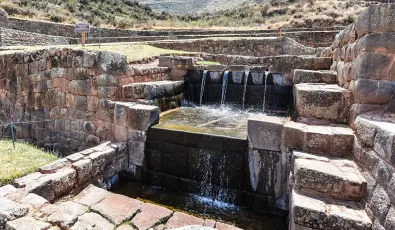
Terraces: The terraces are located to the southeast of the archaeological monument, comprised of seven levels with water channels and staircases, serving agricultural functions where maize and beans were cultivated.
The Cliff Tombs: Parts of the funerary contexts looted by treasure hunters and local inhabitants are observed in the two rock formations that form the archaeological landscape of Waqrapukara. Nonetheless, evidence of their funerary structures, which were attached to the rock outcrop, remains. Some of these mummies are displayed in the art rooms of the schools in Acomayo and Wayqui.
Quarry: On the northwest side, behind the main plaza, lithic elements were extracted for the construction of the archaeological site. Here, the Inca path that surrounds the rock outcrop can be observed, running down the slope to the platform of the adjacent sector.
The Lookout: Located at the top of the terraces, above the rock outcrop, where two rectangular-plan enclosures are observed, offering a vantage point to view the entire valley.
Pacarina: refers to a rock shelter where the first inhabitants of the Qankis ethnicity lived. It is located in the sector of the terraces to the southeast and contains a lithic altar where ceremonies thanking Mother Earth were conducted.
Its Architecture
The archaeological site of Waqrapukara showcases an architectural design that reveals various stages of construction over time. A notable feature is the presence of doorways with double and triple jambs, typical of significant temples. Moreover, the retaining walls and the superimposition of dwellings illustrate the continuous use of the site across different historical periods.
Interesting Facts or Legends Associated with the Site
Rebellion of Ttito Ccosñipa
Ttito Qosñipa, a native of noble descent from the Qercepci nation, which occupied the lands of Saihua and Huayqui, was incensed by a new edict issued by Wayna Qapaq. This decree required all Qercepci to pay heavy tributes in textiles for the Inca soldiers' uniforms. Deeply aggrieved by this, Ttito Ccosñipa led the Qercepci in defiance against the sovereign of Cusco, sparking a battle between the Inca army, led by Wayna Qapaq, and the Qanchi nation under Ttito Qosñipa. The confrontation occurred at Phiñaypampa, where the Inca army emerged victorious and took the Qanchi soldiers prisoner. Ttito Qosñipa retreated to Waqrapukara and stayed for a month. Ultimately, the Incas cut off their water supply, forcing the Qanchis to surrender. They were taken to Cusco for execution, but Wayna Qapaq spared their lives, albeit after cutting off their ears as a sign of their rebellion, before they joined the Inca army in battle against the Cañaris in Ecuador, from which they emerged victorious.
Other Archaeological Sites within Cusco—Waqrapukara Route
Around the Pomacanchi Yanacocha lagoon and Pampamarka, we find:
- Pumachapi Pucará: As the name suggests, "fortress where the puma is located," this hill is situated northwest of the town of Pomacanchi. Its natural terraces are scattered with ceramic fragments, worked stones, obsidian shards, and quartz. The hill serves a religious function, overlooking the entire valley formed by the Pumachapi and Qayoqa rivers.
- Q’anchoqa Pucara: Located southeast of Pomacanchi, this site contains ceramic fragments, obsidian shards, and natural terraces.
Conchacalla Pucará: Situated southeast of the district capital on a high hill, the summit features circular diorite stone constructions. These dominate the lake and the plains, and a network of water channels, crystal-clear springs, and Inca-period tombs are on the slopes of this hill. - Andenes de Qero and Hatun Qero: Built by Inca Huascar, located in a bay formed by Lake Pomacanchi, it features a special microclimate where a succession of artificial terraplenes is observed.
- Q’atoqa: Located in the northwest area of K’ullupata, characterized by constructions of long pens and small circular housing structures made of sandstone and limestone corresponding to the Wari period.
Other nearby sites near Waqrapukara include Ayapukara, Llaqtapukara, Tambopukara, and Kullupata.
Flora, and Fauna
Flora
Common species observed throughout the site include tasta (escallonia myrtilloydes), Kjayara (Puya weberbaueri), Ichu (Jarava ichu), Paqo (Aciachne pulvinata), Poa anua, (Hipochaeris sp), Valeriana (Valeriana sp), Q’era (Lupinus sp), Mullaka (Mulebeckia volcanica), C’hillca (Bacharais latifolia), Tayanka (Baccharis odorata), Cheqche (Berberis humbertiana), Mutuy (Senna birrostrys), Llaully (Barnadesia horrida), Roqe (Colletia spinosissima), Chachacomo (Escallonia resinosa), and Kiswar (Bubbleja Incana).
Fauna
Among the common species observed throughout the site are the Green and White Hummingbird (Amazilia viridicauda), Huallata (Chloephaga melanoptera), Andean Woodpecker (Colaptes rupicola), White-crested Elaenia (Elaenia albiceps), American Kestrel (Falco sparverius), Giant Coot (Fulica gigantea), Andean Tinamou (Nothoprocta pentlandii), Black-crowned Night-Heron (Nycticorax nycticorax), Andean Gull (Larus serranus), Carunculated Caracara (Phalcoboenus megalopterus), Cinnamon Teal (Spatula flavirrostris), Puna Teal (Spatula puna), Andean Lapwing (Vanellus resplendens), Culpeo (Pseudalopex culpaeus), Taruca (Hippocamelus antisensis), and Molina's Hog-nosed Skunk (Conepatus chinga).
Travel Tips
Where to stay?
There are no hotels at the archaeological site, but there is a flat area suitable for safely camping in tents we bring along. Near the archaeological site, in the towns of Huayqui and Campi, lodging is available at about 15 to 20 soles per night per person, but do not expect luxurious accommodations as this town is just beginning to train for tourist reception.
What to bring?
To avoid discomfort and inconvenience during our trips, we should always carry the following:
- Identity documents (DNI or passport): To register in the visitor's log with the park ranger.
- Warm clothing: If you plan to stay overnight, bring a waterproof jacket, winter hat or chullo, cotton socks, and warm trousers.
- Trekking shoes or sneakers: To prevent accidents as the terrain is somewhat rugged.
- Sunscreen: To protect our skin from burns since, at this altitude the sun's rays are more intense.
- Sunglasses: To protect our eyes from the intense midday sun.
- Hat: To prevent sunstroke and sunburn during the day.
- Water bottle: To stay hydrated during the walk.
- Snacks: Bring nuts, coca or lemon sweets, chocolate energy bars which will help give you strength along the way.
- Trekking poles: This will help lighten the walk.
- Camera: To capture the beautiful landscape and moments.
- Personal medicines: For headache, altitude sickness, muscle pain, stomach infection, and always carry coca leaves.
- Cash: In case of any unforeseen expenses or if you wish to buy a souvenir from the place.
Routes and Highlights within Waqrapukara
- Main Plaza: Here, visitors can see the two horn-shaped rock outcrops known as “waqras,” surrounded by rectangular enclosures with double and triple jambs and a retaining wall that encircles this space, offering views of the natural landscape.
- The Portals: Positioned at the extremes of the main plaza facing the abyss.
- Sacred Enclosure of the God Wiracocha: Located east of the central plaza, this area features a priestly chamber with three niches and shares a square plaza with a stone altar.
- Ceremonial Enclosures: Found at the northern and southern extremes of the main plaza, these are rectangular enclosures with niches featuring double and triple jambs facing south and eastward, respectively.
- Enclosures: Situated on nearly all the platforms of the archaeological site and the terraces, these served as dwellings, ceramic production, and textile workshops.
- Uña Waqra: Located to the east of Waqrapukara, this area features pre-Inka circular-plan enclosures and an Inca wall with passageways and staircases.
- Terraces: Positioned southeast of the archaeological monument, these terraces, comprised of seven levels with water channels and staircases, were used for agricultural purposes, mainly to cultivate maize and beans.
- The Lookout: Situated atop the terraces above the rock outcrop, this site offers excellent opportunities for capturing photographs of the archaeological site or the valley landscape.
While at Waqrapukara, it is recommended:
- Be very careful with heritage, as it belongs to everyone, not just one person. It must be preserved over time so that future generations can learn about its culture and history.
- Follow the marked path, as this allows us to continue the tour without missing a sector.
- Do not touch the lithics (stones), as our hands sweat. Salts that contact the lithic (stone) activate microorganisms that accelerate deterioration, causing disintegration.
- Not to climb on or lean against the walls, as our personal weight will increase the pressure on them, causing them to collapse eventually.
- Do not pick up organic and inorganic matter from our food within the park, as we can alter the cultural and archaeological landscape.
- To take care of the flora and fauna of the place to prevent the extinction of species.
- Fires are allowed only in authorized areas.
Some questions about Waqrapukara
Why is it called the Qankis nation?
In memory of the seven sons of the patriarch of the Qanchis, who lived in these pacarinas; the word Qanchis in Quechua is equal to the number seven, hence the name "Qanchis" or "Qanchi."
What was the initial name of Waqrapukara?
The original name of Waqrapukara was "Llaqtapukara," until in 1934, a group of mestizo intellectuals planned to recover the archaeological remains; they cleaned up the site and renamed it WAQRAPUKARA due to its resemblance to the horn of cattle.
Who built Waqrapukara?
The site was initially constructed by the Qanchi ethnicity between 1500 BC and 1000 BC during the Auqarunas period. It was completed during the period of Inka Wayna Qhapaq and Qanchimachu. It was rebuilt by Ttito Qosñopa with the help of Qanchimachu, who participated in the constructions of Saqsaywaman and Waqrapukara because he had powers over stones and water.
Who was T’tito Qosñipa?
Also known as Wayna Qanchi, he was a Qanchi leader, Curaca of Hanan Saya of Pomacanchi, native of Sayhua. From a young age, he stood out for his military prowess; this Qanchi and his soldiers climbed the hills and pukaras almost as fast as smoke, leaping from one rock to another with such ease that after the war in Piñiypampa, he was named the leader of the Mot’oqanchis.
Why is Waqrapukara considered a place of great importance?
Due to the presence of doorways with double and triple jambs. Let's not forget that in the Inka era, only places of great importance were built this way, which mostly belonged to sanctuaries.
In what year was it recognized as an archaeological monument?
Waqrapukara was declared a pre-Hispanic archaeological monument on July 17, 2007, in its classification as an archaeological landscape.
Final Thoughts about Waqrapukara
If you are an adventurer who loves unique landscapes, take the opportunity to explore Waqrapukara, a new tourist destination in Cusco. This magical and impressive space will have a significant emotional impact on you. You can spend the night and have tea in front of the archaeological center, where there are still no restrictions, allowing you to fully enjoy it, obviously without causing damage to our culture and heritage of our ancestors. Come and enjoy this unique experience in the highlands!




Add new comment