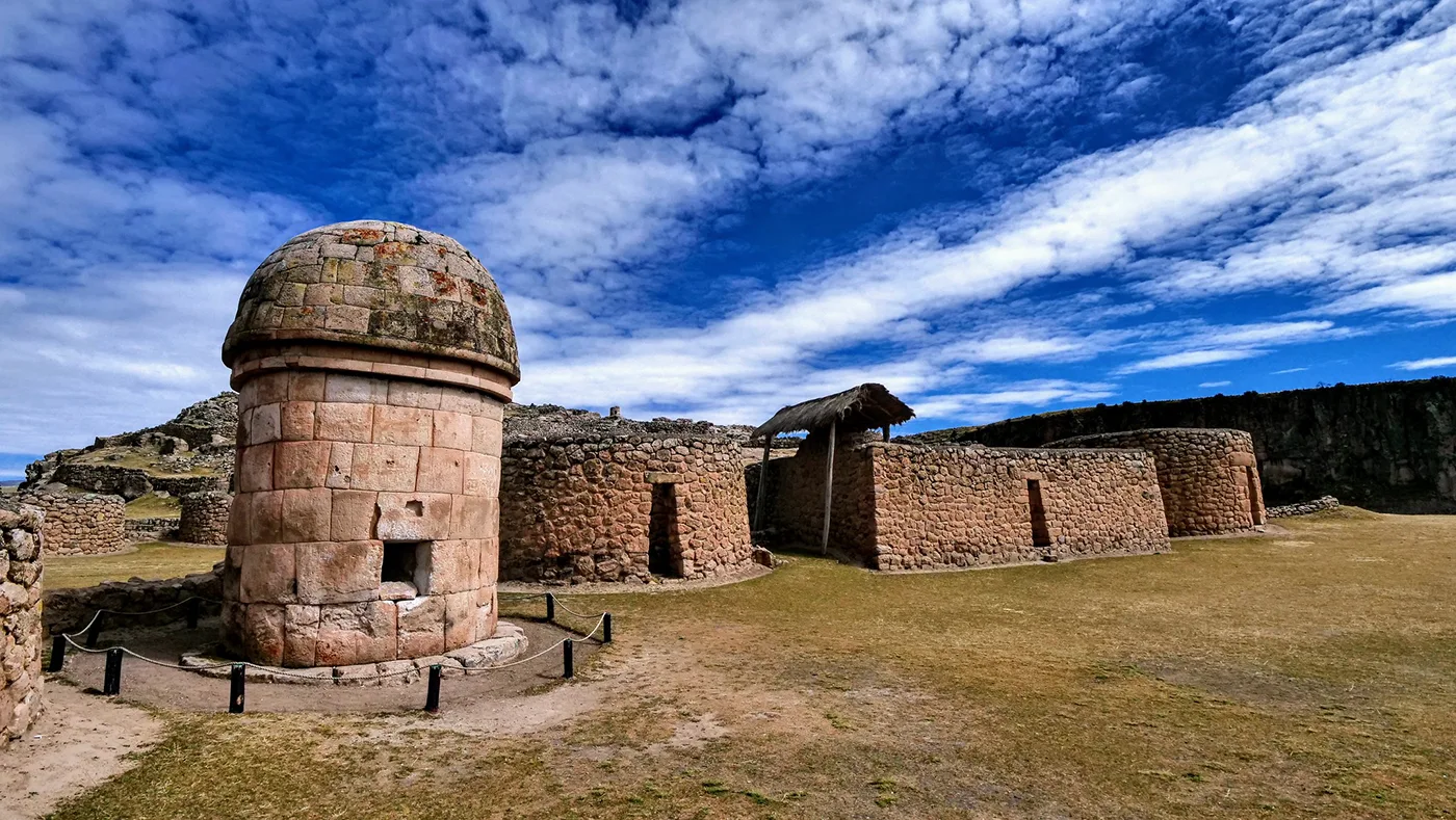
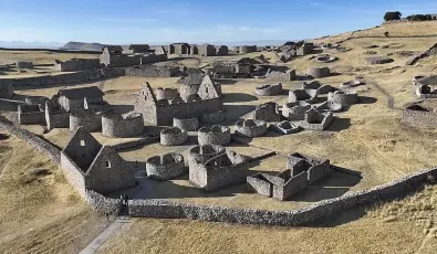
In the heights of Cusco lie the archaeological remains of Maukallaqta, where the waters of the Apurímac River flow and originate. This site was once home to ancient populations, whose history is etched into the landscape. Maukallaqta showcases legendary funerary structures known as chullpas and ritual dwellings built upon the terraced platforms along the Apurímac River.
Nestled amidst a queuña forest and rocky mountains draped with ichu grass, this site was once the residence of the Canas and Inca warriors, influenced by their neighbors, the Qollas. This has made Maukallaqta a natural paradise crafted from stone. Read on to discover more about this fascinating site!
What is Maukallaqta, and where is it located?
Maukallaqta is an ancient pre-Inca archaeological site located in the tranquil community of Manturca, 26 km from Yauri in the Coporaque district, Espinar province, Cusco department. It sits beside the calm waters of the Apurímac River, in the imposing Virginniyoc canyon, at an altitude of 3360 meters above sea level.
The term 'Mauk´allaqta' derives from two Quechua words: 'mawk´a' meaning ancient, and 'llaqta' meaning village, city, or nation, translating to "ancient village or old city" in Spanish.
A Quick Look at Mauk’allaqta's History
Before the Inkas
The K'ana people first lived in the ravines of Mauk'allaqta, in places like Suero, Trapichipampa, Hatúnmayu, and Coporaque. These areas were home to the earliest K'ana folks from the pre-ceramic Paqarimuq Runas era.
Originally called Hanq’oqawa, Mauk’allaqta was the ancient capital of the K'ana lands. It was part of the Hanansaya region and was settled by the first Canas communities—the Pacari, Pomacanchi, Quispillacta, Chacra, and Chiriuna. They lived there until they clashed and were overtaken by neighboring groups through various tribal wars.
Wari and Qolla Influence
Once the Waris conquered the Canas, they built a worship center and a noble cemetery at Mauk’allaqta. The site had rectangular buildings used for social, ceremonial, and ritual activities, including mallquis storage, while circular structures were used as homes or storage spaces.
Mauk'allaqta is filled with ancient stone and mud structures, both circular and rectangular, which are 4m and 6m in size, featuring what are now known as chullpas. Here, mummies of their leaders were kept in perfectly crafted stones, under finely made semi-domed roofs. Leaders like Campana and Cari led their people into battles against the Canas, leading to ongoing disputes and takeovers.
Inka Dominance
From 1260 to 1290, under Inka Lloque Yupanqui, the Canas had to navigate internal conflicts and threats from the Ayarmacas. They tightened control over administration, religion, politics, and the economy, focusing on livestock and mining in places like Orcopampa and Arcata.
Later, from 1400 to 1438, under Inka Viracocha, the Canas became key allies of the Inkas, who moved them from high mountains to the valleys, close to major roads. Post-conquest, they concentrated on making textiles, milling grains like quinoa and kañihua, and supplying meat and wool to the Incas.
In 1600, the Inka commanded skilled workers from the Qolla Nation to start building Mauk’allaqta.
Colonial Period
During the Spanish colonial era, this area was part of a district set by the Spanish crown for tax purposes, under the rule of Cusco and the Royal Court of Lima. In 1536, the locals rebelled against the encomendero Diego Rodríguez Alemosin, famously making him drink molten gold for his greed. This act led many to leave for Coporaque and perform the Tipi ritual, which involved breaking ceramics and marking them with an X to symbolize mourning.
Today
Nowadays, people often confuse the archaeological sites of Mauk’allaqta in Paruro and Arequipa with Mauk’allaqta of Espinar. While both are unique in their own right, Mauk’allaqta of Espinar stands out for its chullpas of varying sizes and its location along the Apurímac River in the Virginniyoq canyon.
At Maukallqta, you'll find structures with double-frame doors, two-story buildings, ceremonial fountains, patios, water channels, Kallankas, plazas, and Qolqas. The site gained fame from the writings of historian Pedro Cieza de León, who celebrated it as one of the five great oracles.
How to Get There?
You can get to Mauk’allaqta using one of three unpaved routes:
From Cusco: Start with a 5-hour scenic drive along the Cusco-Espinar highway. Follow this with a breezy 30-minute journey on the Yauri-Suyckutambo dirt road, leading directly to T’aqrachullo.
From Arequipa: Take the PE–34A route to Juliaca, then head off at Patahuasi towards Colca. You can also go through Chivay or Callalli to reach Sibayo, then detour to Caylloma, right at the Arequipa and Cusco border, cruising through Sucykutambo and T’aqrachullo to get to Mauk’allaqta.
From Puno: Travel the PE–34A from Juliaca towards Santa Lucia-Lugunillas. At Imata, take the turnoff to Negromayo-Héctor Tejada-Yauri-Suyckutambo. The route passes through Sucykutambo and T’aqrachullo, leading straight to the heart of Mauk’allaqta.
Each route offers unique landscapes and a glimpse into the diverse geography of the region. Consider doing it from Cusco, as it is the fastest and most convenient way to get there.
When to visit
The best months to visit are from April to October, when it's dry and clear—perfect weather for some adventure sports like rafting or kayaking, and great for enjoying the scenery.
What to see at Mauk’allaqta Archaeological Site
Mauk’allaqta is known for its ceremonial and religious significance, closely tied to the Apurímac River and famous for its many chullpas. Some experts even call it an oracle of the southern zone, packed with cultural artifacts and built on tough, rocky ground. The design reflects both highland and Inka styles, where locals lived alongside their ancestors.
Kallanka Inka
These buildings, also known as tambos or royal houses, are right next to a colonial Christian chapel. They’re large, two-story structures with gabled roofs, serving as rest spots for travelers on the Qhapaq Ñan and venues for public gatherings.
Terraces
Locals shaped their land by creating terraces, or 'pata patas', not so much for farming but more for aesthetic purposes. These terraces hosted buildings, chullpas, and plazas for social and ceremonial events.
Chullpas or Tombs
Across the site, you’ll see funerary towers of various sizes, especially around the central plaza. These are made from sillar stone blocks, assembled with mud mortar, and were used to honor important community members, with only local leaders attending the ceremonies.
Enclosures
The site includes enclosures from pre-Inka, Inka, and colonial times, showing a mix of circular and rectangular layouts. Some have been turned into chapels during the colonial period.
Plazas
The plazas were where everyone gathered for big social events, sharing food and drinks, enjoying dances, and participating in ceremonies. They were key spots for the local communities and royal groups.
Rock Paintings of Ekiwasi or Virginniyoq
Near kilometer 26 on the way to Yauri, check out the rock paintings depicting a hunting scene with camelids, showing a hunter with darts chasing wild camelids. These are some of the oldest rock arts found in the Cusco region, dating back to the pre-ceramic period.
Architecture
The archaeological zone is set between the rock of Qoyllorpampa and Muro Pukara, with underground passages known as chinkanas linking to the community of Kaq’ekullo. The area, set in the Tocaza and Sillapaka geological formations, features caves and holes connecting to other communities, all under the watchful eyes of local Apus like Kinsachata and Salyuta.
Important Places within the Archaeological Site of Mauk’allaqta
The archaeological site is divided into five zones:
“Plaza pampa”: Located northeast of the archaeological complex, starting from the sillar mounds to the bank of the Apurímac River, where we observe rectangular floor plan enclosures corresponding to a kallanka with 12 niches and a Christian chapel.
“Yuraq Torriyoq”: Located southeast of the archaeological site, where we observe a cylindrical structure with a circular floor plan corresponding to a 5m high chullpa surrounded by several circular enclosures around a large plaza.
“Pukara”: Located in the central part of the archaeological site, protected by a perimeter wall with a single entrance, featuring a lintel and steps leading to a sacred space that serves as a cemetery for the site's ancient inhabitants.
“Pukara Khepa”: Located to the north of the archaeological site, on a slope called Pukara. Circular plan enclosures were structures for burial due to their smaller diameter, and rectangular plan enclosures scattered without any order adapted to the terrain.
Aqotambo: Located on the eastern side of the archaeological site, above a rocky promontory up to the Anicero stream. There we observe a group of square and rectangular base enclosures functioning as lookout points due to their commanding view of the archaeological site.
Similar Sites to Mauk’allaqta
The religious area of Mauk’allaqta, known for its funerary buildings called chullpas, closely resembles the archaeological site of Sillustani in Puno. Both sites feature a similar layout where individuals from the same lineage or caste were buried. Solemn ceremonies honoring the deceased, attended by the local elite and hierarchy, were a central aspect of both Mauk’allaqta and Sillustani.
Weather
The whole area of Mauk'allaqta experiences two distinct seasons:
- Rainy Season: Lasting from September to March.
- Dry Season: Spanning from April to August.
During sunny days, temperatures can range from a maximum of 24°C (75°F) to a minimum of -20°C (-4°F).
Flora
The site is situated within the puna ecosystem, featuring a variety of flora including:
- Qeuña (Polylepis besseri)
- Kcolle (Buddleja coriacea)
- Chachacomo (Escallonia resinosa)
- Ichu (Stipa obtusa)
- Kiswar (Buddleja incana)
- Thola (Baccharis dracunculifolia)
- Chillca (Baccharis latifolia)
- Llaulli (Barnadesia horrida)
- Checche (Berberis spp.)
- Local Puya Raimondi (Puya titanca)
Fauna
The area boasts diverse wildlife, including:
- Vizcacha (Lagidium viscacia)
- Field mouse (Apodemus sylvaticus)
- Andean fox (Lycalopex culpaeus)
- Puma (Puma concolor)
- Taruca (Hippocamelus antisensis)
- Eagle (Buteo polyosoma)
- Condor (Vultur gryphus)
- Wild guinea pig (Cavia tschudii)
- Partridge (Nothoprocta pentlandii)
- Kingfisher (Merops apiaster)
- Andean woodpecker (Colaptes rupicola)
And numerous other species call this area home.
Interesting Facts or Legends Associated with the Site
The Journey of the Ayar Brothers
Legend has it that the four Ayar brothers, emerging from the cave of Pacarectambo (Paruro) and representing the four tribes of the Apurímac valley, set out in search of fertile lands. During their journey, they founded the town of Mauk'allaqta.
Marriage of Inca Huayna Capac to Princess Kana
Between 1494 and 1528, during the reign of Inca Huayna Capac, he sought the hand of Princess Kana, daughter of the lord of the Canas, as a gesture of gratitude and goodwill. Princess Kana accepted his proposal, leading to a lavish celebration that strengthened ties with the formidable Canenos, thus solidifying Inca dominance. This marriage proved strategically advantageous for the state, securing the cooperation of the Canas in expanding towards Qollasuyo and cementing the alliance between the Incas and the Canas. As a display of his wealth, Huayna Capac sent gold and silver artifacts, which unfortunately fell victim to looting by the Spaniard Diego Rodriguez later on.
The Mallquis
The deceased were given special attention, with the Hatunrunas responsible for wrapping them in blankets to preserve their bodies for centuries, leaving their faces uncovered. Members of their Panaka would whiten their faces and wear gold masks as a sign of mourning before storing the bodies in their quarters. These mallkis, or mummies, were periodically brought out to ensure family prosperity, good harvests, and taken along on military campaigns for victory.
Other Sites You Can Visit on the Espinar-Mauk’allaqta Route
K’anamarka
The archaeological zone of K’anamarka is located in the community of Chani K’anamarca in the district of Alto Pichigua, Espinar province, Cusco department, about 15 km northeast of the capital of Yauri, at an altitude of 4040 meters above sea level.Machupuente or Apachacu Colonial Bridge
Considered one of the first bridges of the colony, it was built over the Apurímac River, which flows from north to south forming a narrow canyon of white granite, carved in sillar stone and bonded with lime mortar, including its two side railings, polished by water erosion.Paris Pukara
Located 18km from the community of Coporaque, it presents two well-defined areas: an urban sector and sector two, where enclosures of rectangular and circular floor plans are observed, as well as a wall enclosing the space.Laqoyoq or Devil's Throat
A magical place located on the left flank of the Espinar Suykutambo road at the height of the white bridge, where the course of the river cuts through the rocky outcrop, creating a unique panorama that seems to stop the movement of the water, suggesting that it does not flow, with dark green waters due to the presence of abundant algae that appear black from a distance.Tres Cañones
This is a regional conservation area featuring mountainous landscapes with incredible rock formations that form stone forests 80m high, created by the canyons of Virginniyoq, which at night project silhouettes of animals and extraordinary beings, highlighting three alleys of volcanic soil formed millions of years ago by the erosion of the Callumani, Cerritambo, and Apurímac rivers.Colonial Church of Coporaque
Located southeast of the road leading to Santo Tomas, within the church, the magnificence of the main altar is visible, along with paintings from the Cusco school, baroque altars in gold leaf, its exterior facade with a bell tower, and other editions with fine stone carvings. It is open for visits in April and particularly during festive days.Pinturas rupestres de Ayamac’hay
Located in the Aldigua ravine of the Echoccollo community (Suyckutambo), about 2 km from the Tres Cañones, the archaeological site known as Aya Mach’ay features rock paintings on the interior walls of a rock shelter. These paintings include two panels that date back to the archaic period.
Travel Tips
Admission Prices
These archaeological sites in southern Peru have been recently studied, restored, and handed over to the local communities for protection. That means there are no entrance fees. All you have to do is sign in to the visitor's logbook and identify yourself.
Opening Hours
The site is open for visitors from 7:00 AM to 5:00 PM.
What to Bring?
For this impressive journey to Mauk’allaqta, it is recommended to bring:
- Hat: With a broad brim that covers part of the shoulder to prevent sunstroke and sunburn.
- Sunblock: To avoid burns caused by sun exposure.
- Sunglasses: To protect your eyes from the sun's rays during the day.
- Light Clothing: Comfortable for walking.
- Warm Clothing: To stay warm in cooler temperatures.
- Water: To stay hydrated during your walk.
- Snacks: Bring dried fruits or cold meals, as there are no stores or kiosks at the site.
Recommendations at Mauk’allaqta
- Be Respectful of Heritage: These sites belong to everyone, not just one person, and must be preserved over time so that future generations can learn about their culture and history.
- Follow Marked Paths: This will help you navigate the site without missing any sections. If you are traveling alone, consider following a travel plan and download a GPS app.
- Avoid Touching the Stones: Our hands can sweat and contain salts that, when in contact with lithic materials (stone), activate microorganisms that accelerate deterioration, causing disintegration.
- Do Not Climb or Lean on the Walls: Adding our body weight increases pressure on these structures, leading to potential collapses.
- Dispose of Organic and Inorganic Waste Properly: Keeping the park clean helps preserve the cultural and archaeological landscape.
Maukallaqta is worth it!
Do you love a good challenge? Well, reaching Mauk´allaqta is quite the adventure due to its remoteness, but the breathtaking landscape makes it all worthwhile. Just keep in mind the first step is to leave Cusco bright and early for Espinar, then continue your journey to Mauk´allaqta. You'll be amazed by its architecture and the warm hospitality of its locals. And don't forget to dip your toes in the majestic Apurímac River for a refreshing break. Come and embark on this journey – Mauk´allaqta is waiting for you!
References
Ministry of Culture Cusco, final report "archaeological research of Mauk´allaqta" 2005, Jose Pilares Daza.


Add new comment