


Waqrapukara is one of the most impressive archaeological landscapes in southern Cusco. Set among mountains, terraces, rock formations, and cliffs overlooking the Apurímac Canyon, this ancient ceremonial center holds history, symbolism, and a rare natural beauty.
In this guide, you will learn more about Waqrapukara, how to get there from Cusco, how much the entrance fee costs, which routes are available, how difficult the hike is, its history, and the key tips you should keep in mind before your trip.
What is Waqrapukara?
Waqrapukara is an important ceremonial center of Canchis origin that was later adopted by the Incas. Here, the Qanchis deity Teqsi Pachacamaq Wiraqocha was worshipped. According to this tradition, this sacred place honored the creator of the sun, the moon, and the stars.
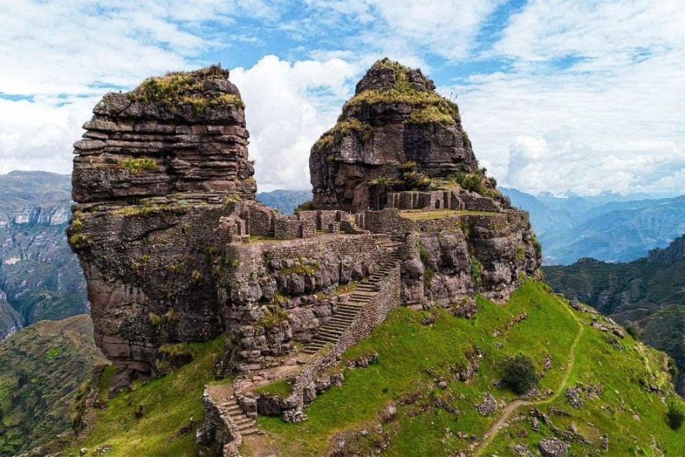
The site rises on a dramatic geological outcrop surrounded by approximately eight retaining terraces, creating a winding profile beside cliffs that reach up to 300 meters in height. Inside, visitors can see different enclosures, passageways, and a central plaza.
Waqrapukara is also believed to have been a place where offerings and sacrifices of camelids of different colors, such as llamas and alpacas, were performed as part of Andean ceremonial practices. This ritual character sets it apart from other sacred spaces, such as the temple of Teqsi Pachacamaq Wiraqocha in Raqchi, which was mainly associated with ceremonial offerings.

Where is Waqrapukara located?
The Archaeological Landscape of Waqrapukara is located on the right bank of the Percca River, in the area of the Percca estate, Huayqui community, Acos district, Acomayo province, Cusco region.
- The coordinates of Waqrapukara are: east 0209008.2600 and north 8448423.2630
- Altitude: 4,110 m or 13,484 ft.
How much is the entrance fee to Waqrapukara?
The entrance fee to Waqrapukara depends on your country of origin:
- Peruvian visitors: 10.00 soles
- Foreign visitors: 20.00 soles
Names and meaning of the word Waqrapukara
- The name “Waqrapukara” comes from two Quechua words: waqra or huacra, meaning “horn,” and pukara, meaning “fortress.” This name refers to the two large geological formations that rise above the landscape and look like horns.
- Another name associated with the site is “Llamapukara” or “Pumapukara,” because its rock formations also resemble the ears of a llama or a puma. The first name is linked to the llama herding once practiced in the highlands near the site. The second is related to the town of “Pomacanchi” and its lake, also located in the highlands close to the area.
- In the past, it was also known as “Llacta Pucara.” The word llacta means “town” or “city,” suggesting that this place was once inhabited and also held great ceremonial value for Andean societies.
- A less common name is “Huayqui” or “Huayqe,” which means “brothers.” This name comes from the two rock formations, which are symbolically seen as brothers.
The name Huayqui is still preserved in the town closest to Waqrapukara.
How to Get to Waqrapukara?
There are four main routes to reach the archaeological landscape of Waqrapukara. All of them start from the city of Cusco, following the road toward Sicuani. Along the way, you take the turnoff at the Chuquicahuana Bridge and continue toward the following routes:
Acos - Huayqui Route: Once in the district of Acos, continue to the village of Ch’acco, then pass through Llapaypampa and Campi-P’alta Cancha until reaching the community of Huayqui. From there, the hike begins with an uphill walk of about 1 hour and 30 minutes, followed by an additional 15-minute stretch before arriving at Waqrapukara.
Pomacanchi - Santa Lucia Route: Once in the district of Pomacanchi, there are two ways to reach Waqrapukara. From Acomayo, continue to the village of Churacca, then pass through the community of Santa Lucía until reaching the end of the road at Santa Lucía. From this point, the hike to Waqrapukara takes approximately 2 hours. This is the most popular route among visitors. Another option is to enter through the village of Chosecani and reach Waqrapukara after a 5-hour hike.
Acomayo - Ramal Huascar / Pitumarca Community Route: Once in Acomayo, there are two possible routes to Waqrapukara. One option is to start at Ramal Huáscar, continue toward the village of K’enter, and then complete the journey to Waqrapukara. Another option is to enter through the community of Pitumarca, passing through the village of Paclla before reaching the site. In both cases, the hike takes around 5 hours.
Sangarará Route: From the district of Sangarará, follow a dirt road to the area known as Llank’ipata. From there, begin a downhill hike toward Waqrapukara. The walk takes approximately 5 hours.
Waqrapukara Hike Difficulty
The difficulty of the hike to Waqrapukara can vary depending on the starting point of the route.
Hike through the Apurímac Canyon: from Santa Lucia, Campi, or Huayqui
- Difficulty: Moderate to challenging.
- Approximate hiking time: 2 to 3 hours
- Type of route: An uphill hike with beautiful views of the canyon and the Apurímac River. The trail combines both sunny and shaded sections.

|  |
This canyon hike also gives you the chance to see and visit other attractions, such as pre-Inca tombs and rock paintings.
Hike from the highlands: from Sangarará, Pitumarca, or Chosecani
- Difficulty: Moderate to challenging.
- Approximate hiking time: 4 to 5 hours.
- Type of route: A longer hike across mountains and open plains before descending to Waqrapukara. Sun exposure is stronger along this route.

On this hiking option, you can enjoy views of high-Andean lagoons, herds of alpacas, and wide open landscapes.
History of Waqrapukara
Pre-Inca Period
In its early stages, Waqrapukara was inhabited by the ethnic groups known as the “Chelq’es and Maskas,” who occupied these territories. Later, the K’ana nation settled in the area. They were the inhabitants of the legendary city of Ancocagua or T’aqrachullo, and were later displaced by another human group that settled in the territories of Pomacanchi and Acomayo, giving rise to the Qanchi ethnic group.
The Qanchis lived near the paqarinas, or sacred places of origin, close to Waqrapukara, Tambomayo, Puma Orqo and Willkacalle, Suyt’upukara, Qero, and Pumawasi. From this area, the Qanchis began to expand their territory, settling in the highlands, including the pukaras of Machupitumarca, Salqapukara, and the upper areas of Salqamayo.
During the Late Intermediate Period, the Qanchis had direct contact with the people of Paruro, who came to Waqrapukara to offer their Colcha-style ceramics. At the same time, the Killke, also known as the Early Incas, were present in the area and lived at the site for a long period before the arrival of the Incas.
During this period, the construction of pukaras near the high plateau in southern Peru became a common settlement model. These structures were built on hilltops or at strategic points along mountain routes, making them naturally defendable. In other cases, they were fortified for protection.
One example of a pukara near Cusco is Puka Pukara, an archaeological site commonly visited during the classic Cusco City Tour.
Inca Period
Waqrapukara was originally built as a llaqta by the Qanchis. Around 1000 BC, during the period of the Auqarunas, it was transformed into a pukara with the purpose of defending its territory from other ethnic groups.
It was during this time that conflicts arose between the K’anas and Qanchis, as well as between the K’anas and Chumpiwillkas. The Chumpiwillkas were especially interested in the cornfields of Llaqtapukara. Later, Waqrapukara became the final refuge of the Qanchi ethnic group, turning into a fortress under the command of Ttito Qosñipa against the Inca army.
After the Qanchis were subdued by the Incas, the Incas maintained indirect control over them. When T’ito Qosñipa rose to the rank of general in the Inca army, he improved and reorganized the architectural structures at Waqrapukara. This is why powerful Inca-style constructions can still be seen at the site today.
Along the route to Waqrapukara, there are several funerary chambers, collective and individual tombs, skulls with cranial deformation, and even some with signs of cranial trepanation. These remains are evidence of the warlike past of this area of the Apurímac Canyon.
 |  |
Colonial Period
In 1581, the province of Acos appeared in the provisions of Viceroy Toledo as part of the Cusco repartimiento. In 1613, an ecclesiastical division of Cusco took place, dividing the region into 13 corregimientos, with Acomayo forming part of the 4th corregimiento of Quispicanchi.
History of the Town of Huayqui or Wayquey
After the indigenous resettlements promoted by Viceroy Toledo, the town of Huayqui was founded. This settlement was established over ancient Inca agricultural terraces, of which only a stone canal that crosses some of its streets still survives today.
The architecture of this picturesque town preserves a colonial style, as does its urban layout, which follows the typical colonial grid pattern.
In addition, the town of Huayqui still preserves Quechua street names, such as Chaupy Calle, Hawa Calle, Hermita Kuchu, Wasa Calle, Munay Pata, Paqchapata, Kátu Moqo, and others.
Waqrapukara Today
In 2017, Waqrapukara was recognized as an archaeological landscape by the Ministry of Culture of Peru. As a tourist destination, it is still not very crowded, allowing visitors to enjoy the landscape freely without large numbers of people.
Within this landscape of rocky outcrops, cliffs, and deep ravines, condors nest, making it possible to spot the flight of the condor around midday.
What is the Best Time to Visit Waqrapukara?
The best months to visit Waqrapukara are from May to October, when there is little to no rain. The site has a camping area, so visitors can set up tents freely and enjoy both the archaeological site and the beautiful landscapes that surround it.
Weather in Waqrapukara
The weather in Waqrapukara is semi-dry and cool, with an average annual temperature of 12 °C to 14 °C and two well-defined seasons:
- December to March - Rainy season, with the highest amount of rainfall.
- May to July - Dry season, with sunny days and clear skies.
What to See in Waqrapukara?
Places inside the Waqrapukara Archaeological Site
Inside the Waqrapukara Archaeological Site, you will find several important areas with direct access:
- Main Plaza: The central plaza is located in the upper part of the site, where two horn-shaped rock outcrops, known as “waqras,” rise above the landscape. It features double- and triple-jamb niches. This entire space appears to be enclosed by a retaining wall and was likely accessed by important members of the elite, such as priests and representatives of other ethnic groups who came to perform ritual ceremonies and astronomical observations.
- Gateways: These are located at the ends of the main plaza and were built with finely cut stone. They feature two and three jambs, a style associated with Inca temples and with ceremonies honoring the moon and the sun.
- Towers: These two natural circular towers rise at the southern and northeastern ends of the esplanade. There is no easy access to them, but it is believed they may have served as lookout points, reachable only by skilled climbers.
- Ceremonial enclosures: Located at the northern and southern ends of the main plaza, these rectangular enclosures had a ceremonial purpose and were used for offerings.
Other enclosures can also be seen in the northern section, including two rectangular structures with double- and triple-jamb niches. These face south and east, respectively, and may have been used to observe solstices and equinoxes. - Enclosures: These are circular dwellings distributed across nearly every platform of the retaining walls. Rectangular enclosures can also be seen on the terraces of Waqrapukara. They likely served as homes, pottery workshops, and textile production spaces.
- Uña Waqra: Located to the east of Waqrapukara, this area is connected to the main site by a rocky outcrop that continues like a natural bridge. Within this space, visitors can see circular pre-Inca enclosures, passageways, and stairways that were later enclosed by an Inca wall.
- Terraces: The terraces are located southeast of the archaeological monument and are made up of seven levels with water channels and stairways. They had an agricultural function and were used to grow corn and beans.
- Funerary contexts on the cliffs: On the two rock formations that form part of the Waqrapukara archaeological landscape, remains of funerary contexts can still be seen. Many were looted by treasure hunters and local residents, but traces of the funerary structures attached to the rock outcrop remain. Some of these mummies are exhibited in the art rooms of schools in Acomayo and Wayqui.
- Quarry: Located on the northwestern side, behind the main plaza, this was the area where stone materials were extracted for the construction of the archaeological site. Here, you can also see the Inca trail that surrounds the rocky outcrop along the slope connecting with the nearby platform.
- Viewpoint: Located in the upper part of the terraces, on the rocky outcrop, this area contains two rectangular enclosures and offers wide views of the entire valley.
- Pacarina: This refers to a rock shelter where the first inhabitants of the Qankis ethnic group are believed to have lived. It is located in the terrace sector to the southeast and contains a stone altar where ceremonies were performed in gratitude to Mother Earth.
Other Archaeological Sites along the Waqrapukara Route
Around the lagoons of Pomacanchi, Yanacocha, and Pampamarka, you can also find:
- Pumachapi Pucará: As its name suggests, Pumachapi Pucará means the fortress where the puma is found. Located northwest of the town of Pomacanchi, it is a hill with natural terraces. On the surface, fragments of pottery, worked stones, obsidian flakes, and quartz can be seen. It had a religious function and offers views of the valley formed by the Pumachapi and Qayoqa rivers.
- Q’anchoqa Pucara: Located southeast of the town of Pomacanchi, this site contains pottery fragments, obsidian pieces, and natural terraces on its surface.
- Conchacalla Pucará: Located southeast of the district capital, on a high hill, this site has circular stone structures made of diorite at the summit. It overlooks both the lake and the plain. On the slopes of the hill, there is a network of canals, clear-water springs, and tombs from the Inca period.
- Terraces of Qero and Hatun Qero: Built by the Inca Huascar, these terraces are located in a bay formed by Lake Pomacanchi. The area has a special microclimate and features a sequence of artificial platforms.
- Q’atoqa: Located in the northwestern area of K’ullupata, this site is characterized by long enclosure-like structures and small circular dwellings built with sandstone and limestone, corresponding to the Wari period.
Other sites near Waqrapukara include Ayapukara, Llaqtapukara, Tambopukara, and Kullupata.
Flora and Fauna

Flora
Some of the common plant species found along the route and throughout the archaeological landscape include:
Tasta (Escallonia myrtilloydes), Kjayara (Puya weberbaueri), Ichu (Jarava ichu), Paqo (Aciachne pulvinata), Poa annua, Hipochaeris sp, Valeriana (Valeriana sp), Q’era (Lupinus sp), Mullaka (Muehlenbeckia volcanica), C’hillca (Baccharis latifolia), Tayanka (Baccharis odorata), Cheqche (Berberis humbertiana), Mutuy (Senna birostris), Llaully (Barnadesia horrida), Roqe (Colletia spinosissima), Chachacomo (Escallonia resinosa), and Kiswar (Buddleja incana).
Fauna
Some of the common wildlife species that can be seen along the route and around the archaeological landscape include:
The Green-and-white Hummingbird (Amazilia viridicauda), Andean Goose (Chloephaga melanoptera), Andean Flicker (Colaptes rupicola), White-crested Elaenia (Elaenia albiceps), American Kestrel (Falco sparverius), Giant Coot (Fulica gigantea), Andean Tinamou (Nothoprocta pentlandii), Black-crowned Night Heron (Nycticorax nycticorax), Andean Gull (Larus serranus), and Mountain Caracara (Phalcoboenus megalopterus).
Tips for Visiting Waqrapukara
Where to Stay?
- There are no hotels at the archaeological site, but there is a designated camping area where you can spend the night comfortably.
- The towns of Huayqui and Campi offer basic tourist services, with accommodations that cost around 15 to 20 soles per night per person.
What to Bring?
To avoid discomfort and enjoy your trip without problems, it is always a good idea to bring the following:
- ID card or passport: You will need it to register as a visitor with the park ranger.
- Warm clothing: Bring a waterproof jacket, a wool hat or winter cap, cotton socks, and warm pants, especially if you plan to stay overnight.
- Trekking shoes: Useful for walking safely, as the terrain can be uneven in some sections.
- Sunscreen: Essential to protect your skin from sunburn, as the sun is stronger at this altitude.
- Sunglasses: Helpful to protect your eyes from the intense midday sunlight.
- Hat: Important to help prevent sunstroke and protect yourself from the sun during the day.
Water bottle: To stay hydrated throughout the hike. - Snacks: Bring nuts, coca or lemon candies, and chocolate energy bars to help keep your energy up along the way.
- Trekking poles: They can make the hike easier and reduce pressure on your knees.
- Camera: Perfect for capturing the beautiful scenery and special moments.
- Personal medication: Bring medicine for headaches, altitude sickness, muscle pain, and stomach issues, and consider carrying coca leaves.
- Cash: Useful in case of any unexpected expenses or if you want to buy a local souvenir.
Once in Waqrapukara, We Recommend:
- Respect the cultural remains and do not pick up pottery fragments, stones, or any other archaeological objects.
- Always follow the marked trails to avoid getting lost and to protect the most sensitive areas of the site.
- Do not touch, lean on, or climb over walls or stone structures, as contact and weight can damage them.
- Do not leave trash along the route; carry your waste with you until you find a proper place to dispose of it.
- Protect the local flora and fauna: do not pull out plants or disturb wild animals.
- Make campfires only in authorized areas and always take the necessary safety precautions.
Visiting Waqrapukara is a chance to discover a quieter side of Cusco, where Andean history, highland landscapes, and views of canyons and valleys come together in a truly unique experience. If you would like to explore this impressive archaeological site in a more organized, safe, and meaningful way, we can help you plan your visit to Waqrapukara on your next trip.
Waqrapukara FAQs
Can you visit Waqrapukara on a one-day tour from Cusco?
Yes, Waqrapukara can be visited on a one-day tour from Cusco. The tour usually starts very early, around 4:00 a.m., and returns to Cusco at approximately 7:00 p.m.
Is Waqrapukara suitable for children or older adults?
It can be suitable only if children or older adults are used to hiking at high altitude and are in good physical condition. The hike takes place above 4,000 meters above sea level, so lack of acclimatization, sun, wind, and steep sections can make the route more demanding.
What is the easiest route to reach Waqrapukara?
The easiest route is usually the one through Santa Lucía or Huayqui, as long as the vehicle can reach the closest points to the trailhead. These options reduce hiking time and are better for travelers who want to visit Waqrapukara in one day from Cusco.
Are there bathrooms, shops, or restaurants near Waqrapukara?
Tourist services near Waqrapukara are limited. For this reason, it is best to bring water, snacks, cash, and everything you need for the hike. Some nearby villages may offer basic services, but it is not recommended to rely on them during your visit.
Do you need a guide to visit Waqrapukara?
A guide is not always mandatory, but it is highly recommended, especially if it is your first visit. Waqrapukara has several access routes, high-altitude areas, trails that are not always well marked, and archaeological sectors that are much easier to understand with historical and cultural explanations.
Is there cell phone signal at Waqrapukara?
Cell phone signal may be limited or intermittent along the route and within the archaeological landscape. For safety, it is best to download maps, share your itinerary before leaving, and avoid depending completely on your phone for navigation during the hike.


Add new comment